24 September, 2006

Turkey Street to Chigwell – Essex innit! London Loop Sections 18 and 19

I suppose it had to come really. I had to leave Hertfordshire and enter Essex. There were some pleasant spots on this walk and the weather couldn’t be bettered, but Essex is always a bit of a come down.

The day began at Turkey Street station (see Quin Parker’s amusing entry on Turkey Street in his zone 6 guide) and continues following the Turkey Brook where I walked last time. Coming to a major road I had to stop off to look at Unity superstore, one of the North London Branches which was a very fine store. I bought my lunch and one or two other things then continued with the walk walking down some dull suburban streets and through a dull suburban park. It seems that the council here do not provide seats in the parks so be warned if you’re going and take your own. Enfield Lock on the River Lea Navigation was pleasant with the lock keeper’s cottage dating from 1879 and the cruciform Lee Conservancy offices from 1907. I walked very briefly by the Lee Navigation to Swan and Pike Pool where there was a loop information board. Then it was time to walk by the fast flowing River Lee. The river is deep in places and shallow in others and I saw some fish in it. I crossed a modern steel bridge over a flood relief channel into the County of Essex and came to the Sewardstone Marshes Nature reserve. I nearly stopped for lunch here but decided to press on to follow the route to a farm with a big old farm house from the eighteenth century I would suppose. This looked quite attractive but it was surrounded by a high wall so a picture was just about impossible. The path ran through the fields up to the Sewardstone hills. These hills are wooded with some very attractive views over the Lee Valley Reservoirs, which supply around a quarter of London’s water. I stopped for my lunch overlooking the reservoir and then pressed on to Carroll’s Farm which is a charming traditional weatherboarded Essex farm. I also walked along the road and came upon half a cast iron hat coat and umbrella stand. How this came to be beside a road I don’t know but I took a picture of it anyway.

The path took me through the Scout Association National Headquarters at Gilwell Park and through some pretty meadows where I got lost but not unpleasantly. It would have been good for sunbathing but I pressed on to rejoin the loop into the Chingford part of Epping Forest. Some boys (of all ages) were playing with bows and arrows on the footpath, which I thought was a bit dangerous. Epping Forest has been owned by the Corporation of London for many years and preserves a piece of old England for public recreation forever. There is also Queen Elizabeth’s Hunting Lodge which has been restored by the Corporation. 
It was originally built as a Grand Standynge to allow spectators to watch the stag hunt – the original Grandstand. The great staircase in the lodge is round a square newel to allow stately processions to climb the stairs. It is said that Queen Elizabeth rode her horse up the stairs – who knows. The lodge had a display of Tudor food and heraldic banners and is quite well interpreted although the idea of keeping servants and others separate did not begin until regency days when corridors first appear.

People were having fun in the forest in all kinds of ways but I soon left them behind to cross the River Ching (into Essex again) and came to the village of Buckhurst Hill (very posh with lots of large houses. I then went through a little green lane down to the Central Line and passed into one of the council estates erected for Londoners in the Roding Valley. It is very council estate-ish here. There is a large recreation ground with a lake excavated to provide gravel for the M11 motorway nearby. I walked round the lake and crossed the River Roding by a bridge then walked round a large recreation centre and school, named after a guru. I wouldn’t like to go to a school named after a guru! I crossed the motorway and came into Chigwell amongst the bandits and bank robbers. I caught the train home from there.

17 September, 2006

Manchester

I've been to Manchester before, and no doubt I'll go again but what I observed this time was the statue of Queen Alexandrina Victoria in Picadilly Gardens. This is a grade 2 listed building.

The Queen is crowned and sat on a throne looking completely debauched. She looks like she has been out night clubbing until six in the morning and has drunk rather a lot of alcohol as well as being tired. She cannot even hold her sceptre straight. It really is a bad representation.

16 September, 2006

Cockfosters to Turkey Street: a stroll along the Turkey Brook London Loop Sect 17.

This section is a part of the Loop that manages to miss out almost all of the worthwhile sights as it meanders along the Turkey Brook.

The first part after the car park and cemetery runs through Trent Park which contains an obelisk to the memory of the duke of Gloucester and another one built as an eyecatcher in the landscape. It certainly does catch the eye, but the loop does not pass it, except from a distance. In the middle of summer here you can’t see the house at Trent Park, which is a campus of Middlesex university, because all the trees are in the way. Another sight missed.

The loop then takes in some pleasant open fields where there were cows grazing. They came over to see who was wandering round the edge of their field. Here’s a picture of one of them

The next section was a lot more of the same although the fields were empty, except for a few horses. I got slightly lost here and walked up a farm track towards Botany Bay cottages, but soon got back on the loop again through a memorial plantation called Brooke Wood, although I don’t know whose (or what’s) memorial it was – Mr or Mrs Brooke or Brooke the racehorse – could be any of those. Although the Ordnance Survey map says it is on Cuckold’s Hill, so I wonder if there’s a story there?

Here’s a picture of the farm.
The path came out at a road called the Ridgeway and there I broke to search for lunch – it seemed quite a long search to a shop but I found one.

After lunch the next section led me down a drive to a farm and a mini version of Beckingham Palace called the Red House stuck in the country. Hilly Fields Park is rather pretty with the Turkey Brook running through it and wooded valleys including a bandstand in the valley.

I crossed a hazardous road into the grounds of Forty Hall which is another interesting place the loop misses. I don’t have time on these trips to do these things as I need to get the walk done! The old channel of the New River runs through here almost completely dried up. We met the end of the new river on the Capital Ring at Clissold Park. The new river isn’t either new or a river but is still quenching the thirst of Londoners after 400 years. The course was straightened in the 1850s and the old channels were left to their own devices. The path led by a fishing lake in Forty Hall grounds, then comes out near a Thames Water establishment which IS the New River which ducks under the Turkey Brook at this point. I crossed a road by a foot bridge (no hazards here) then walked by a cemetery and crematorium into a suburban street – yes, you guessed it – Turkey Street. The station was waiting for me so I left the loop at this point and joined Coöperative member and staff at the Thames Festival, which was thronged! Posted by Picasa

13 September, 2006

Shoreham

Shoreham station is miles away from the sea and I only got as far as the river Adur and what might be the finest church in Sussex. Certainly the church was an impressive Romanesque church, and although I was prevented from walking in the nave and aisles by a heavy metal railing I was awed by the place, which had been once much bigger. The village has two bridges made of concrete over the Adur, one for foot passengers which slides back to allow ships to pass, and one for cars. I don’t know if the car bridge moves. Shoreham village has never come to terms with its traffic problem and there was a constant stream of cars in the main street.
The pictures show the church and the little museum.
 Posted by Picasa

Worthing

I visited Worthing more to see where it was than anything else and to walk along its art deco pier. The front resembles very closely the picture in my 1937 guide book, however the lido (no swimming pool) and the seafront gardens seemed to emanate decayed decay. The views from the front are of the distant seven sister cliffs and Brighton which appeared bathed in sunlight when I called.

The town museum had a good collection including prehistory and costume, which readers will know I’m not interested in, but there were some items of civic memorabilia which I am.

There were some shops also.
The pictures show the pier and the lido
 Posted by Picasa

12 September, 2006

Brighton

What more can I say about Brighton? I visited some places this time that I hadn’t visited before, mostly on the west side of Dyke Road, my attentions are usually confined to the east. I saw St Michael and All Angels Church, which is really two churches, the new nave and aisle having been added as an extension to the former nave and two aisles. I did rather better for Kings England Books here as a bookshop had a stock of them at reasonable prices. It just goes to show that you don’t need to go to a book town.

I was down at Mike and Ken’s for the duration of my stay and we entered the pub quiz at the Star Bar, acquitting ourselves very well I thought, although I made a blunder on the flavour of fennel leaves. I didn’t walk on the pier this time but walked down to Hove Lagoon, where the film stars have their retreats right on the beach.

My first day was spent visiting Preston Manor and church, the Manor being a museum of life in Edwardian days for both the couple who lived in the house and their 15 servants. The fifteen did include three gardeners but even so I’m not sue what they would have done all day, even if clothes were more difficult to launder, fires required laying and lighting and rooms required scrubbing rather than hovering. They can’t have scrubbed them every day. The reason it was given to the Council appears to be that the money for its upkeep ran out. The house and its curators were pleasant and informative but did not mention the ghosts that are supposed to haunt the place, besides a reference to an extraordinary séance in the guide book. This had taken place in 1896 after mysterious apparitions and inexplicable phenomena had troubled the family. There is a collection of 18th century furniture and a large pride of Buddhist lions in the cabinet in the dining room.


The redundant church of St Peter at Preston was locked when I called, so I had to borrow the key from one of the pubs in the village. Inside there were stained glass windows showing the cardinal virtues of Faith, Hope and Charity (also translated as love). There are wall paintings, including one showing the murder of Thomas a Becket, the Archbishop of Canterbury murdered at the altar by drunken knights who considered that they were doing the King’s bidding. These paintings were saved from a fire one hundred years ago.
Brighton’s new public library, the Jubilee Library, is housed in a futuristic building, giving much convenience to its readers. The photos show this and the weather vane on the old church of Brighton, St Nicholas.
 Posted by Picasa

11 September, 2006

Hay on Wye

Hay is a book town with more than 30 bookshops, and is a beautiful bus ride through orchards and valleys from Hereford. It is not particularly special architecturally but I thought the bookshops would be good and reasonably priced. They were good but not cheap. I did spend a few pounds on books but there were very few in the Kings England Series that I like (and collect) and the few there were, were overpriced. I did the rounds of the bookshops and quite enjoyed it but I doubt I will go back there again.

10 September, 2006

Hereford

Hereford

I moved on from Cardiff by train to Hereford where I was to stay for a few days to go to Hay on Wye. Hereford is also in a beautiful setting on the Wye. Travelling up with Robert and one of the Coöperative College academic Staff, and had a jolly journey – not very frequent on the railways today.

Hereford is a pleasant cathedral city, although the cathedral was largely rebuilt (or, as they called it then, restored) in the nineteenth Century. It is also headquarters of the SAS, an elite British Army Squad.

After I had found a hotel, I went to look around the main drag of the town. The place had a large number of public houses full of young people, probably some of whom were pretending to be SAS but I suspect most were farmers sons. Nevertheless, there was some top totty on display, and I do like my eye candy.

My first port of tourism call was the Conningsby hospital and Blackfriars Priory ruins.
The hospital is an almshouse foundation by the Order of St John of Jerusalem and there is a Saint John’s Ambulance station next door to these pretty cottages built in the characteristic local pink stone. I did not get to see inside the almshouse grounds but the priory, which was founded by the black prince stands in a pleasant rose garden, with a fourteenth century preaching cross which was set up by the black friars, also known as the Order of Preachers, and this is where the friars would preach to the multitudes.
It is a survivor as very few such crosses have survived. After this, it was time for Sung Eucharist in the Cathedral Church of Saint Mary the Virgin and Saint Ethelbert the King. The congregation were a little bit on the elderly side but the hymns and the service were beautifully sung by the Cathedral choir which had just returned after the summer break. Afterwards Coöperative Fair Trade coffee was served in the hall of the Vicars Choral, normally off limits to the public. This is accessed via a medieval corridor with fine carving on its timber roof and there are little houses round a cloister originally built for the vicars choral who provided the music for the cathedral in days of yore. Their dining hall was rebuilt in the eighteenth century and is a finely proportioned and comfortable room.

The Cathedral is also home to the Mappa Mundi, the medieval map of the world and two chained libraries. The Mappa Mundi was drawn on vellum in 1305 by a canon of Hereford. The map was not a navigation aid, it was drawn to show the relation between G*d and his church/people. Hence, it shows Jerusalem as the centre of the world with Jesus presiding over the last judgement. At the outer edge is England, looking remarkably exact, with Lincoln Cathedral proudly shown as scholars consider the canon had once been at Lincoln Cathedral. The second largest chained library in the country has come from All Saints Church, Hereford which is just a short distance from the cathedral, and the largest chained library is the one belonging to Hereford Cathedral itself. The library of All Saints has been sent to the cathedral where a new library building has been built to house the collection. This new library is climate controlled and has all kinds of modern aids to prevent the destruction of the books, except by readers. However, the library has been for most of its existence just anywhere in the cathedral or the church and has still been preserved from destruction. The odd thing about the library is that the books have their fore edges facing the reader and not the spines. This looks wrong to modern eyes but prevents the chains becoming tangled.

My next call was the Borough Museum and Art Gallery which was interesting in the way these museums are. There were fragments of a Roman pavement and good some good dressing up and other interactive games for children.


The Old house in Hereford was formerly the end of Butchers Row in the town. It became a traffic island but a pedestrianisation scheme has made it more accessible. This house was built for a wealthy butcher during Jacobean times and is furnished in the way it would have been in 1621. The ceilings have very fine pargeting and there are old wall paintings that have been removed from other places in the city. The bedrooms are not very comfortable – they would need four poster hangings to keep warm I’m sure.

The time had come to change hotels and I moved to one which was like the American House in Sinclair Lewis’s Work of Art book. The lamps were cunningly placed so I couldn’t use them to read in bed and the television was old. At least the room did not appear to be a working man’s room but more a tourist one, the hotel being thus divided.

One thing it did do was serve local faggots as a snack. As I didn’t meet any local faggots, I was unable to ask them what they thought of this. Perhaps they’d all been eaten as snacks.

Hereford was quite a jolly place to be in with a lot to see. There is a curious suspension bridge over the Wye and some old churches. In All Saints, I found a café offering home made meals, including home made bread to the people in a popular café. There must have been a long tradition of this as there was an old bread shelf, once used to distribute bread to the poor after Sunday service. There were stairs to a former rood loft and a stainless steel modular lavatory that was also popular.

At Saint Peters, I found a tribute to a former incumbent who had helped to establish welfare services in the city including public baths and cottages for the poor. The pubs in Hereford are quite good as befits a garrison town with cheap beer and food.

An enjoyable stay.

04 September, 2006

Cardiff College of Education and Cardiff Bay

I went to this college because of the annual conference of the UK Society for Coöperative Studies which was held here as this is where the Wales Institute of research into coöperatives is based. The college was extraordinarily average but the international company was excellent with Americans, Canadians and Hungarians. On one of the evenings, we went in a coach to see the new attractions at Cardiff Bay. These included the new home of the Welsh National Opera Company and the welsh assembly building. The bay has been improved by keeping it full of water; previously it was smelly mud flats. The Welsh National Opera was a spectacular building faced with copper with half Welsh language and half English inscription on the façade, no doubt making it incomprehensible to all but the 15000 people who speak Welsh. The Welsh Assembly Building looked like a modern airport and the water feature outside it could have done with lighting to ensure that it showed itself off well. The conference went well. A friend of mine called Robert, from Liverpool was also there and we took an opportunity to renew our acquaintance over a game of pool with Richard, the secretary of the UK Society.

Elstree to Cockfosters: Stage 15 of the London Loop. It didn’t seem like ten miles!

The law locks up the man or woman
Who steals the goose from off the common
But leaves the greater villain loose
Who steals the common from the goose.

Ah, Elstree. Is it because it is the end of the Eles Street, the ancient road that we met at Fryent Country Park (see the dead fox picture)? Of course, last time I covered it I did the studios, which are actually in Borehamwood. The Gate Studios have now been demolished since then (I don’t know why as they were used for producing cinema screens: perhaps the cinema building craze has stopped) but I left the station to walk up a street past some film star houses and even some film star flats called ‘Hollywood Court’. It’s great to be back on waymarked paths which make the guidebook redundant. The walk went up a long steep hill then turned into another lane with even bigger film star houses and a slightly steeper gradient. I suspect these houses are now occupied by rice merchants from Park Royal or slum grocers, who seem to be the millionaires now.

I passed by two air shafts for the Borehamwood Tunnel quite close together then descended into the Scratchwood local nature reserve. Every boy from the north who looks wistfully at London has heard of Scratchwood, as it is the last motorway service station on the way from the north. However they may not reach the wood itself (although they might, they’re intrepid those boys) which was quite pleasant as woods go. All the blackberries have now gone to the devil even before Michelmas. He seems to have claimed them early this year for some reason.

Scratchwood was part of a shooting estate but covers some very ancient oak woodlands. They seem a lot better managed than some other woods and the brambles appeared to be cleared quite well. It was a pity that the woods didn’t last very long and I had to go down to the A1(T) which is no longer the Great North Road but at this section is Barnet Way as it is the Barnet By-pass. I had to go a fairly long way down the road to cross by a subway next to the Mill Hill Golf Club (Memberships available - no joining fee!) and then walk back up to reach Moat Mount open space, which was a shooting estate, its mansion long gone and the grounds sold to Barnet Council. I walked up a little stream here and then came out into some open fields with wired off pathways, including some that were only permissive and not public rights of way. There were horned cattle in one field, but very few of them. I didn’t look too closely but I think they were bullocks rather than milkers. I came to another dangerous road and then walked through the London Wildlife Trust Totteridge Fields and crossed a football field and onto the Dollis Brook way. We have encountered the Dollis Brook on the Capital Ring but only slightly. In two of the fields I passed there were fairs going on. The first one I came upon looked like a horse fair with gypsies doing deals on horses and some finely painted gypsy caravans and carts. The other one was more a travelling funfair, perhaps it was Barnet Fair. Barnet fair is cockney rhyming slang for hair (abbreviated to Barnet) and there is a hairdressers near me called Barnet Fair.

After open countryside the Dollis Brook Way (and the London Loop) pass by various council estates which you can date by the manner of construction – 1950s brick, and 1960s prefabrication. Coming into Barnet proper I joined the Great North Road (although alas the little coöp shop has gone so I had to go elsewhere for my lunch) and went straight off it again to cross King Georges Fields. These appear to be named after King George V and possibly purchased for his Silver Jubilee in 1935. These fields were so secluded I took off my T shirt and had a brief sunbathe. There were also views over London although not particularly clear.

The Fields led me to Hadley Green where the battle of Barnet was fought on Easter day 1471. Edward IV overthrew Warwick the Kingmaker who was killed here. As it was a misty day, the soldiers could not see which side they were fighting and chaos ensued. General battle conditions I would have thought. If you wanted to be king in the middle ages you applied to Warwick the Kingmaker (in own handwriting) giving name and names of father and mother (if nun write none). Seller and Yateman ride again. Hadley has some very fine houses on its green including an old manor house with a very fine front door and a turret on its stable block. Not so large but very unassuming is a row of six tiny cottages with paired front doors built in mellow brick – the Sir Roger Wilbrahams Almshouses. Sir Roger was Solicitor General of Ireland in the time of Queen Elizabeth I and he founded his homes for six decayed housekeepers here in 1612. The current residents may have a quiet laugh about that.

There is a pleasant scene by the church with old cottages and the beacon on the church, erected to guide travellers over the wilds of Enfield Chase. The Monken Hadley common is the remains of Enfield Chase which was enclosed in the 1770s and is gated. I had to pass through the white painted gate to continue past some more very large houses to descend into the woods of the common. These woods were quite muddy and I got my boots coated. I soon got to Cockfosters though via more large houses on the common. Cockfosters had a 19th Century church and a 1930s-1950s underground station which proved very serviceable indeed to getting me home after a very pleasant walk indeed. Even the weather was kind.

01 September, 2006

Moor Park to Elstree Walks 14 and 15 of the London Loop

An early start on Friday enabled me to complete this walk. The thing is, in this corner of Norf London it is supposed to be very posh and posh people in the early part of this century did not want the railways bringing day trippers to their lovely areas no thank you! So the railways didn’t come, apart from the Metropolitan Line (see Diamond Geezer for that) and there are very few trains in these oh so outer suburbs.

The walk started and finished on a golf course and even on Friday I was dodging the golf balls although at the Moor Park end there were only one or two golfers at nine o’clock on a Friday morning. One or two cutie pies walking dogs though who flashed me a nice smile and a “good morning”. I soon left the golf course behind and went into Sandy lodge lane with a view over the Colne Valley, and down to the main road, Hampermill Lane and up through some posts to a little playing field for the council estate beyond. I was glad to know that there were some ordinary people living near Moor Park station, even if they were not too near. I walked through the estate into Oxhey Woods, where I managed to get completely lost. There was a waymarker (the first I’d seen that day) but it was of little use. I found I was near the reservoir after a brief excursion down a very exclusive road, probably inhabited either by film stars or Russian ‘businessmen’ or maybe just successful solicitors/estate agents/prostitutes and the like. It was in Oxhey woods that I lost my digicam so there are no pictures of this spot until I get my films developed. If anyone finds it can they please hand it in to the police. When I lost my way I spoke to somebody who was walking around and asked where Pinnerwood Farm (my destination) was and he said that it was over two miles away. It seems like he was a person who only drives because the farm was a lot less than that, but it would be over two miles to drive. Anyway, I got back on the loop with minimal trouble and reached the rather scruffy stud that is Pinnerwood Farm. I took in some beautiful views of Harrow Church, on the hill, and the new Wembley stadium. This brought back memories of the Capital Ring and how much better that walk was signposted. I never got lost on the Capital Ring. What – never? No – never! What – never? Well – hardly ever. And I’ll come back to Gilbert and Sullivan later.

Pinnerwood House (adjacent to the farm) was where Edward Bulwer Lytton lived in the 1830s. He was a politician and a popular author, and actually invented part of the name BovrilTM from his book ‘Vril: the power of the coming race’. Bovril has been in the news today as UnileverTM are putting Beef extract back in the product having taken it out in response to concerns from Muslim countries (where Bovril is a top seller) that the beef was not slaughtered in a halal manner. They must now be sourcing halal beef. Going back a little way to see if I’d dropped my camera, I was accompanied by the farm dog, a Pyrenean mountain dog which is so called because of its resemblance to a mountain. It did not accompany me very far though and I crossed another few fields along the backs of ordinary bungalows. There were an amazing number of apples strewn along the backs of these suburban semis, which was weird. Some were just crab apples but some were of an eatable size. They couldn’t all have been rotten.

After this edge of suburbia with fields on one side and semis on the other I came to a lane that crossed the main railway line to Birmingham and the North West. The bridge was very narrow to accommodate the little country lane this road had been but was no longer and while I was standing there I heard a scrape of metal on brickwork. A bloke in a Bentley, yes a Bentley, had scraped his passenger side on the brick of the bridge!

The road led past a garden centre up through another golf course, with a surprising number of players, including a man out with his son. Golf courses tend to be quite badly waymarked but this one was OK.

I left and entered the ancient earthwork that the Ordnance Survey refers to as 'Grim’s Ditch' but others refer to as Grim’s Dyke. Grim is Wodin, the Norse God, and Grim’s Dyke is an earthwork. I doubt that the people who constructed the earthwork called it Grim’s Dyke. Try as I might I can’t get excited over earthworks. They may be just the iron age equivalent of landfill. Who knows why they built them and really who cares. They are practically invisible now, although I don’t know why that should be. One archaeologist advised me it was earthworm activity. He also advised me that low doors on ancient buildings were because the floors had been built up. I have no reason to doubt these explanations but for earthworks at least perhaps they weren’t very big to begin with.

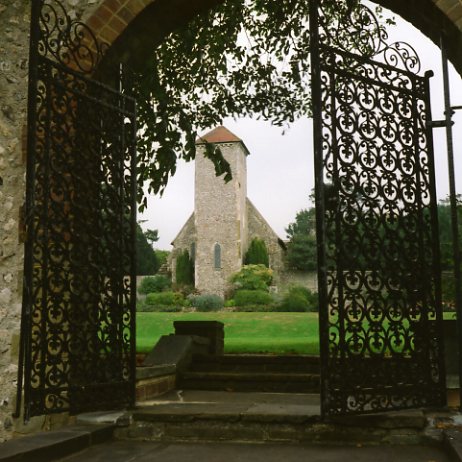
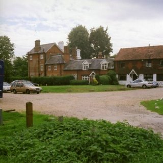
I deviated from the route at Grim’s Dyke to photograph the house (now a hotel) where W.S. Gilbert lived (I did say I’d come back to Gilbert and Sullivan).
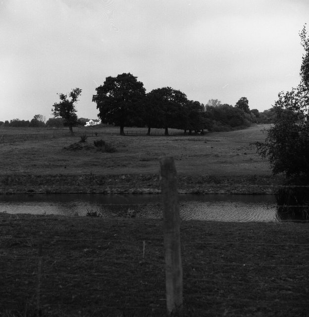
HREF='http://photos1.blogger.com/blogger/5802/1324/640/Grimm%27s%20Dyke570.jpg'> 
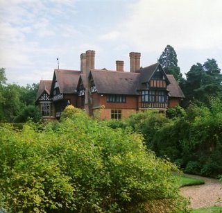
This one would put the others I say to shame. If people today think they are rich living in a house on a street think how wealthy Gilbert must have been as a highly successful dramatist. Followers of Gilbert and Sullivan will note the use of the word ‘dramatist’, which is how Gilbert referred to himself absolutely detesting the word playwright which he used to describe Shakespeare, another pet hate (and mine too). Norman Shaw designed Grim’s Dyke in 1872 in the popular Tudor style. Gilbert moved in in 1890 after his success with possibly during the run of the Gondoliers. He changed the name from Graeme’s dyke. There is lots of ref brick, stone mullions and half timbered gables. The route sadly passed by the lake in the grounds where Gilbert drowned in 1911 while assisting a young girl visitor during a swimming lesson. The lake is just about dry now and there are some rotting remains of a summer house. There is a plaque on the lake to commemorate Gilbert and there is a blue plaque on the house itself.

Leaving the grounds past a British Telecom openreach transmitting station and former gravel workings on the Harrow Weald common, I came onto Bentley Priory circular walk. In a very deserted part of the common, I came upon a man sitting on a bench with a woman. Nothing odd about that except they never moved as I approached and the woman kept her face hidden. Perhaps she was somebody else’s wife.

This part of the walk takes a War Department concrete path. Passing by a bizarre collection of dumped walking frames, I could not see Bentley Priory, which is still an air force establishment with standard hutments and assorted military buildings. I followed the WhD concrete path outside the buildings (admiring the concrete boundary posts) and sitting on a seat while the clock at Bentley Priory struck one. Then time to move on into another unadopted road, with a 1930’s house all in white with a green roof, which rather appealed. In fact, this street was a bit of a millionaires’ row, it’s surprising the number of these I have encountered on my travels. But I must always take the rough with the smooth and I was soon walking through the pretty village of Stanmore with its hall with William Morris Interiors. Stanmore had a pretty village green and two ponds which legend has it were dug by the Romans. And maybe they were – who can tell after all this time.
Passing the ponds I came out by the Royal National Orthopaedic Hospital with its 1930s to 1950s buildings. I walked by a farm then under the M1 motorway at Junction 4. I went onto Elstree Road where drivers were driving far too fast. I don’t want to be a patient at the Royal National Orthopaedic Hospital. I came to a pub called the fisheries inn and had lunch there. Better than average.

The next highlight was Aldenham Country Park and Reservoir. The reservoir was for the Grand Union Canal and was built by French Prisoners of war who made a pretty bad job of it (as one would expect). The dam is now concrete (I hope I haven’t written that as damn elsewhere) and doesn’t leak. Hertfordshire County Council has created a park with a farm and a lakeside walk. I did the lakeside walk in full but didn’t do the farm. Maybe I should, as it is a rare breed farm. Of course the reason rare breeds are rare is that there was something wrong with either the eating quality or the temperament of the animal. The park was a pleasant spot.

Leaving the park I crossed some fields with the spire of Elstree church in the distance. Then, crossing Watling Street I went through some fields with unfriendly notices to enter another golf course. Getting lost on the way I crossed this and went into Parkfield, a park and a field for Elstree. Coming to the road and the end of today’s journey I saw somebody had pulled down the gate studios that were here when I last visited.

An inauspicious start to my holidays.